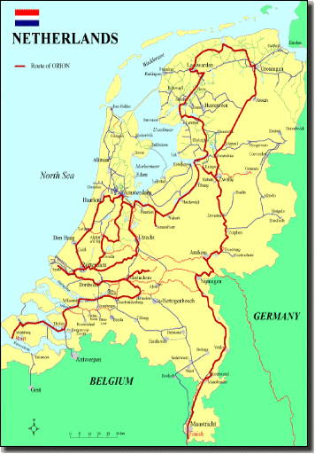

Tom and Carol Sommers completed a season-long trip aboard the Dutch cruiser Orion through all twelve provinces of the Netherlands to research this cruising guide, a supplement to the book “Cruising the Canals & Rivers of the the Netherlands”. The route followed Tom’s personal obsession, searching for Star Forts along the waterways (and finding 29 of the 37 Star Forts in Holland.) Included are maps, photos, touring suggestions and how-to-do-it details.
The basic elements of the book were published in 2010 as “Cruising the Canals & Rivers of the the Netherlands on Orion”, a black&white paperback. Reviewers asked for more maps and color photos; this new edition is a larger format, with full color pages. It displays 191 color photos, 46 maps of provinces and regions showing the route that Orion followed and 42 maps of cities, towns and villages at a scale suitable for a walking tour guide. Waterway facilities, marinas and restaurants are updated through 2019. It is an essential handbook for those making a journey through the entire country or a short cruise in just one province.

Printed book “Orion”
Paperback, 8 inches X 10 inches
253 pages, "perfect" bound.
US$48.50
Available as a Kindle version: From your Kindle, go to the Kindle Store, then Search for "B08467SRWC"
Also available as an immediate PDF Download to your device. (suitable for laptop computer or iPad/Nook/Kindle Fire HD)
PayPal US$28.50
Also see:
Hello Tom, I have downloaded the pdf version of the book and had a quick scan through the pages - the colour images make a great difference, and I am quite sure it will remain a "go to" Netherlands reference book for us motor cruisers (especially those with an interest in the star fort history). Thank you again for the wonderful work you have done, not only with Orion, but with your many fantastic publications on European waterways. Tim
